Kennedy County
Picture of the namesake of one of the cadastral counties that form part of modern day Parkes Shire. This image, circa 1848, is held by John Oxley Library, State Library of Queensland and reproduced on Wikipedia and listed in the public domain
Continuing our series on the counties of the early colony of New South Wales, this post focuses on the county of Kennedy. Part of the 141 counties of New South Wales, Kennedy was proclaimed a county in 1862 (twelve years after the establishment of Ashburnham county). While the name ‘Kennedy’ has many thinking it is Irish, the county is named after a famous Australian explorer who was born in the Channel Islands.
Brief Background to the Maps
In 1825 Royal Instructions were issued to Governor Brisbane ordering a general survey of the colony of New South Wales and its division into counties and parishes. County and parish maps have been used for over 150 years to record Crown land dealings.
Two sets of county, parish and town/village maps were created and maintained by the Department of Lands and its predecessors. One set of maps, for a particular area, was kept at the Local or District offices and a duplicate set for the whole State was kept in the Head Office of the Department.
Both sets were annotated to show changes in the status of the land. The District Office maps, however, often contain information not recorded on the Head Office versions. Once a map could no longer be easily annotated it was ‘cancelled’ and a new edition printed.
State Archives & Records website
NOTE: To understand why counties were so vital to our colonial ancestors
please read the post Ashburnham County
The County of Kennedy
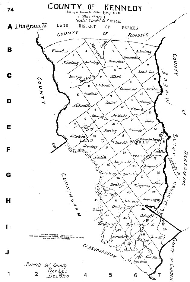
Illustration of the map of Kennedy county. For presentation purposes, the compiler of maps, Alice Jansen, has rotated the map 90 degrees. Narromine County is north of Kennedy, with the counties of Cunningham and Ashburnham to the south. Source: Jansen, A. (1999). County & Parish Maps of N.S.W. with index (map). Emu Plains, NSW: Genial Enterprises page 74
The list of parishes contained in the county of Kennedy are listed below. The map reference relates to the map above (clicking on the images will open them in a new window)
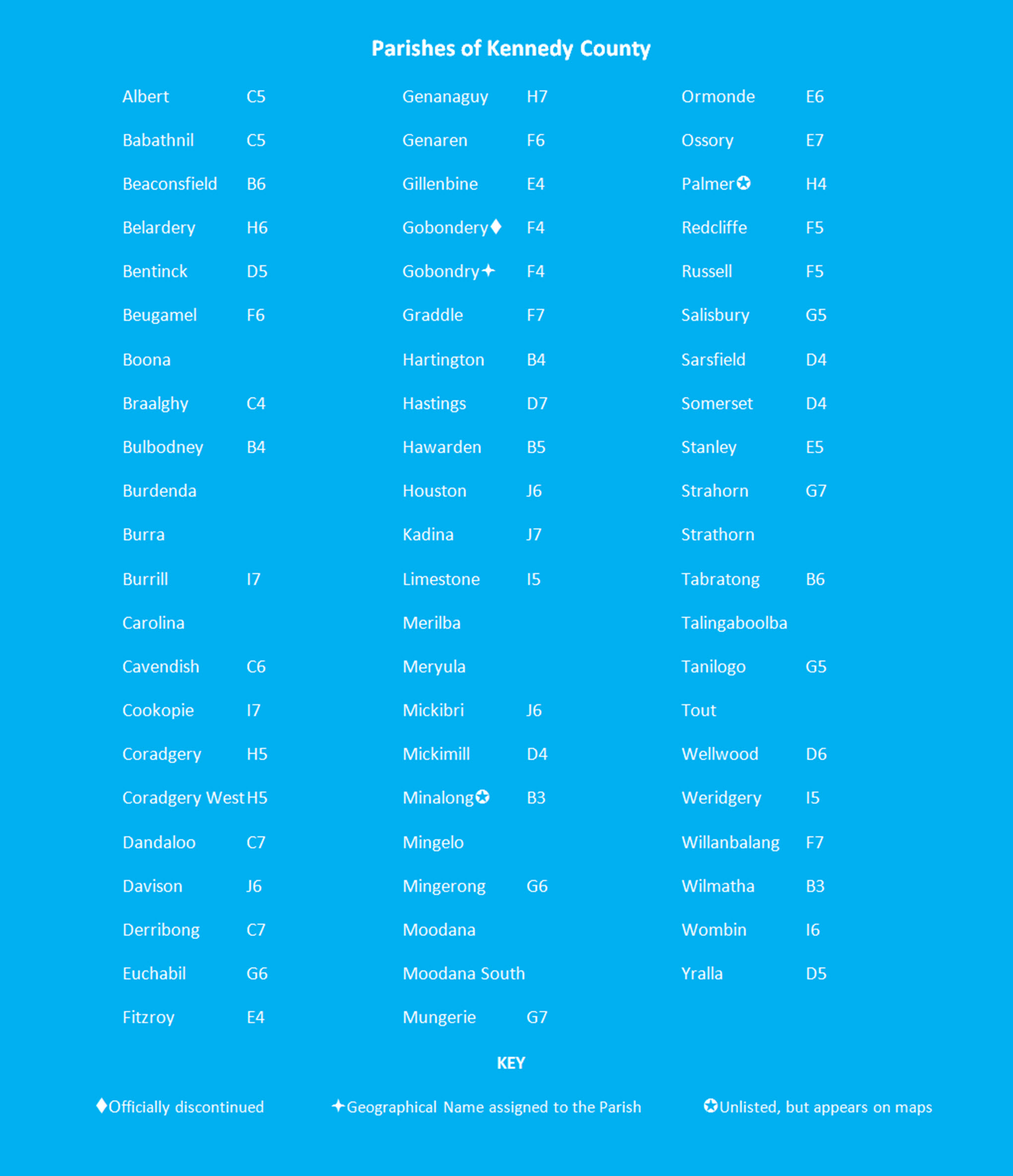
List of parishes within the county of Kennedy, along with map references. Source: Jansen, A. (1999). County & Parish Maps of N.S.W. with index (map). Emu Plains, NSW: Genial Enterprises page 152
Edmund Besley Kennedy
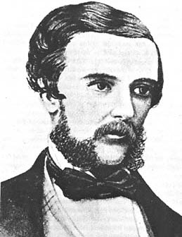
Picture of Edmund Kennedy, originally published in T.L. Mitchell (1838) Three Expeditions Into The Interior of Eastern Australia Source: Wikipedia
According to historical author Edgar Beale:
Edmund Besley Court Kennedy (1818-1848), explorer, was born on 5 September 1818 on Guernsey, Channel Islands, the sixth of eight children of Colonel Thomas Kennedy and his wife Mary Ann, daughter of Thomas Smith, sometime lord mayor of London. All his brothers later distinguished themselves in either the Church of England or the public service, and a strong parental influence in both these directions is obvious. Edmund himself was educated at Elizabeth College, Guernsey, and trained as a surveyor.
Kennedy displayed an interest in surveying while at school at Elizabeth College. Encouraged by a family friend – the naval officer Captain Charles James Tyers – he obtained the necessary qualifications at King’s College London in 1839 (Beale, Edgar (1983) page unknown). Then at age 21 he set sail for Australia, arriving in Sydney in March 1840 on board the barque Globe. Initially he worked for Tyers, joining him on an overland journey to Melbourne and then to Portland Bay for surveying work.
While in western Victoria, Kennedy experienced some controversy. Firstly he met an Irish immigrant, Margaret Murphy, and a daughter was born to the unmarried couple. Sadly this daughter passed away at age five. In addition to this alliance, Kennedy also incurred the wrath of local magistrate, James Blair. He was cleared of the allegations by Superintendent Charles La Trobe but was still recalled to Sydney where he wrote to the governor defending himself of his actions in regards to James Blair, but expressing deep contrition for his relationship with Margaret Murphy.
After a period of inactivity – more due to falling off in land sales which led to less demand for surveyors – Kennedy’s work ethic and talent were again in demand in November 1845 when was appointed second-in-command to Sir Thomas Mitchell.
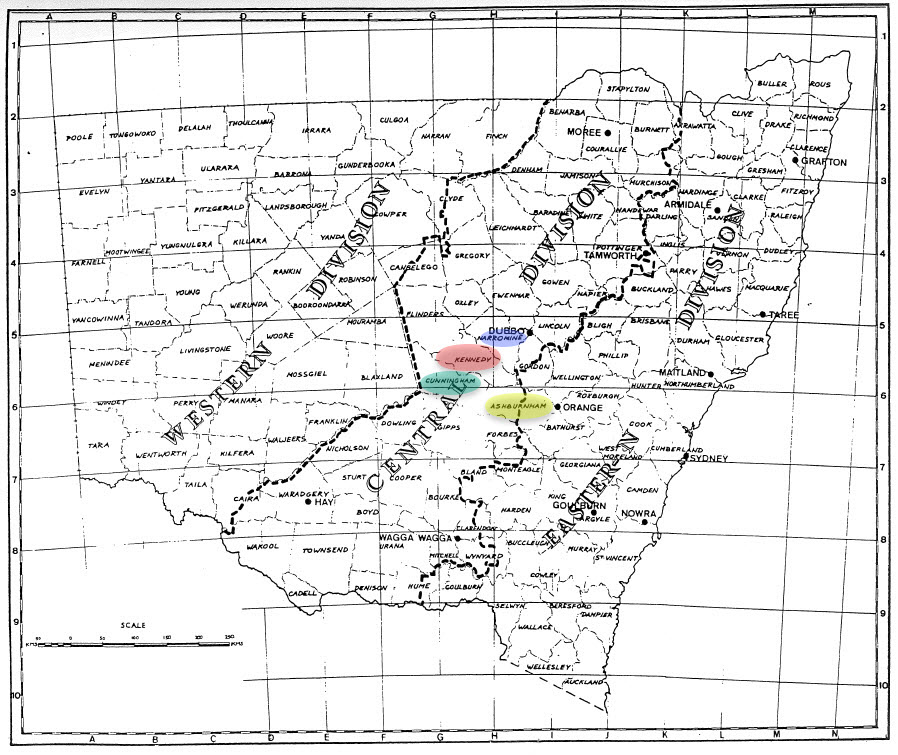
Map of New South Wales counties. In red is the location of Kennedy county, with green for Cunningham, blue for Narromine and yellow for Ashburnham. Source: County & Parish Maps of NSW compiled by Alice Jansen (1991) Genial Enterprises: Emu Plains NSW 2750 (page 5)
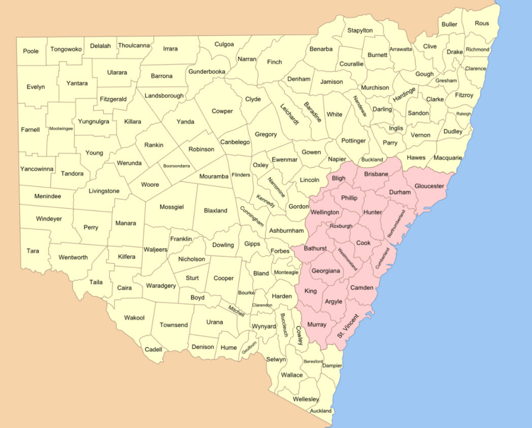
Map of the 141 counties of New South Wales (this is prior to the establishment of the Australian Capital Territory). The four counties that encompass the modern day Shire of Parkes include parts of Kennedy, Cunningham, Narromine and Ashburnham counties. The original Nineteen Counties are shown in pink Source: Wikipedia
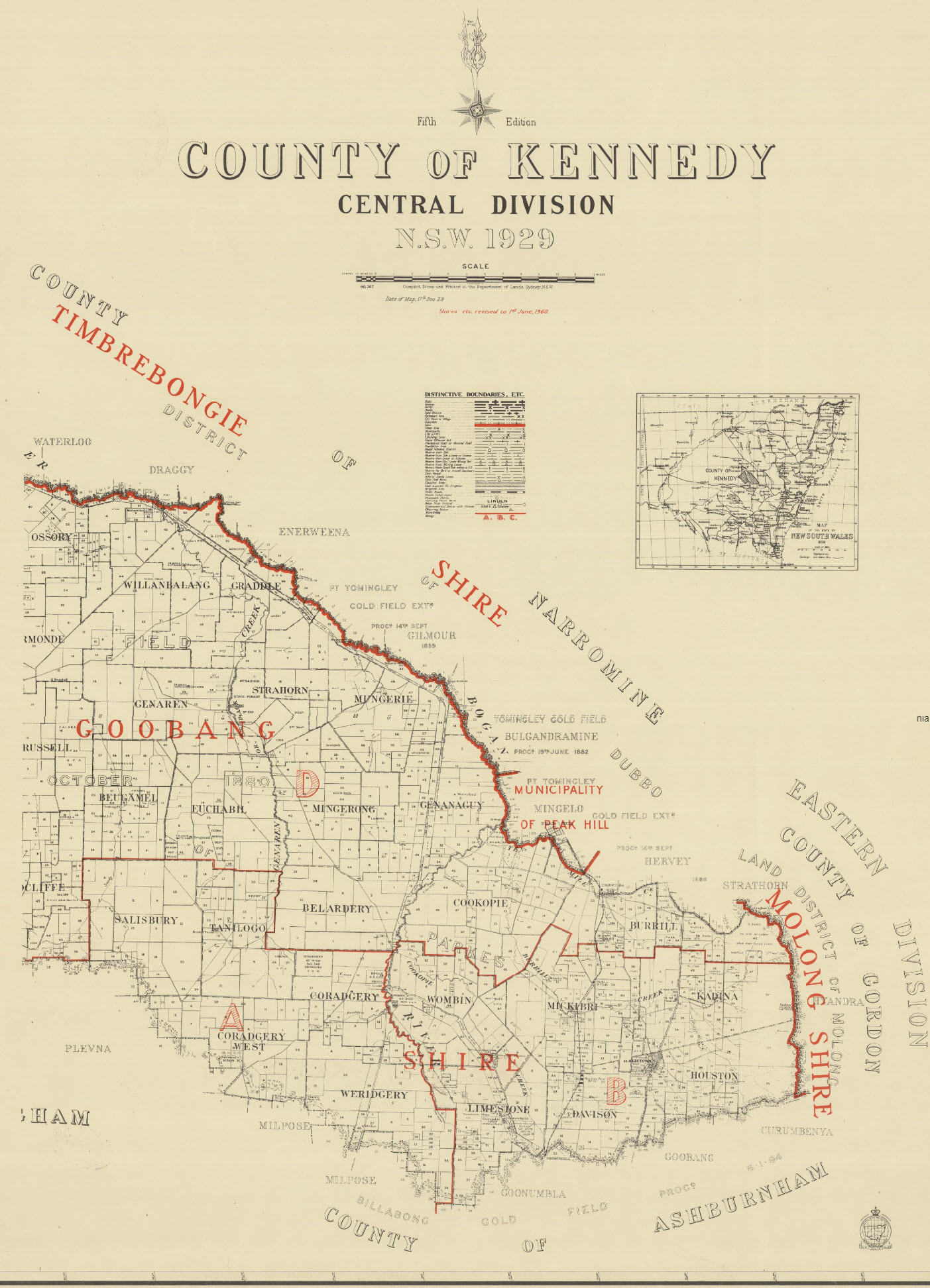
Reproduction of map of County of Kennedy. Most of the now amalgamated Goobang Shire formed a large percentage of Kennedy County. The border to the north meant that most of Peak Hill was in adjacent Narromine County. Source: Trove website
Kennedy the Explorer
Initially Sir Thomas Mitchell was critical of Kennedy but over time came to praise his “temperate and gentlemanly way, and highly honourable principles” frequently recognising his zeal and activity. Kennedy was put in charge of maintaining a base camp for more than four months while Mitchell explored the central west of Queensland. Mitchell discovered a river which he named the Victoria. Mitchell and his entire party returned to Sydney in January 1847.
Mitchell was convinced that the river he had recently named Victoria flowed into the gulf. As it was no more than a theory, Kennedy volunteered to lead an expedition to investigate and prove (or disprove) Mitchell’s theory. On March 13, 1847, Kennedy led a small party of eight men, an Aboriginal boy, pack-horses and three springs carts to Queensland. Following the Victoria, Kennedy and co followed the river. However it didn’t flow north-west to the gulf, as presumed by Mitchell. Rather if flowed south-west to become part of Cooper’s Creek, which did not surprise Kennedy. Due to his finding, Kennedy renamed the ‘Victoria’ the Barcoo and further exploration he came across the Thomson River. The name Barcoo was supplied to Kennedy by the local Aborigines (Joy 1964 page 72) After these discoveries, Kennedy led his team along the Warrego River until its end, then crossed south-east to Culgoa and returned to Sydney. Unfortunately those who greeted him felt underwhelmed by his discoveries, failing to see that he successfully overcame various difficulties. Some did acknowledge his “…sagacity, patience, skill and perseverance” (Beale 1967 page 43)
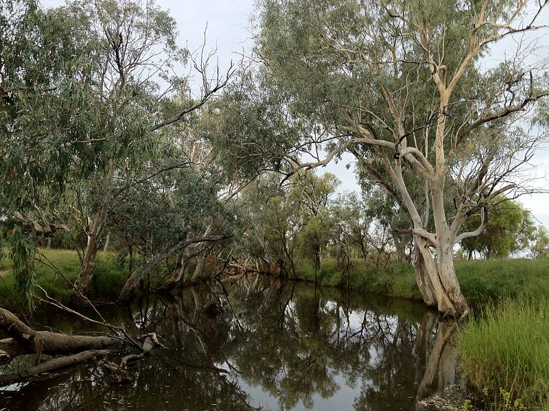
Photograph of a section of Barcoo River, at Tambo, central west Queensland. Kennedy renamed the river after Mitchell initially called it Victoria, believing it to be the same river discovered by Wickham in 1839. The Barcoo is mentioned in some of Banjo Paterson’s poems (notably Saltbush Bill and A Bush Christening) and the Barcoo Salute – brushing away the ever present flies from the face with either hand – is named after the river (there is also a biography by Patsy Adam-Smith called The Barcoo Salute) Source: Wikipedia
Kennedy only needed to wait a few months before embarking on his third expedition. Beale describes the tumultuous and ultimately, final trek of Kennedy:
Within a few months he was again in the field, this time on an ambitious plan of landing at Rockingham Bay to traverse Cape York Peninsula along the east coast to its most northerly point, where supplies would be replenished from a ship waiting at Albany Passage; thence he was to traverse the west coast southwards to link with the recent discoveries of Mitchell and Ludwig Leichhardt, and to return overland to Sydney. Leaving Sydney on 28 April 1848, the landing was made on 24 May. He found, however, that he was hemmed in by mangrove swamps and mountains, and two months later the party was still in about the same latitude and only about twenty miles (32 km) inland. Having ascended the mountains, progress became a little better, but misfortune had beset them: sickness, a growing shortage of stores, extreme fatigue. Yet Kennedy maintained his cheerful manner and good spirits and proved thereby his excellent qualities of leadership. Eventually on 13 November Kennedy decided to leave eight of his thirteen men at Weymouth Bay while he and four others made forced marches to the supply ship for help. Starvation now confronted them all; only two of the men at the Weymouth Bay camp ultimately survived. Meanwhile one of the advance party shot himself accidentally, and Kennedy therefore left the wounded man and two others to look after him—they too all perished—whilst he and the Aboriginal boy, Jackey Jackey, pressed on alone. With weakening strength but superb courage and endurance, they reached to within about twenty miles (32 km) of the supply ship, only to find themselves trapped by the Escape River and its crocodile-infested mangrove swamps and thick scrubs. In the second week of December Aboriginals, who had become increasingly hostile, attacked; Kennedy was speared and soon afterwards died in the arms of the devoted Jackey Jackey, who alone reached the ship and was saved.
Beale (1966) page 43-44
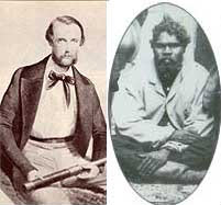
Photographs of Edmund Kennedy (left) and Jackey Jackey. The two were close friends as well as fellow explorers. Source: Eacham Historical Society website
The naming of Kennedy County, in 1862, was part of the then current trend of recognising people who made a contribution to the colony of New South Wales, rather than English aristocrats or military leaders (such as 4th Earl of Ashburnham) NOTE: The state now known as Queensland was part of the colony of New South Wales until 1859.
The above video clip will show readers the type of bush that Edmund Kennedy and Jackey Jackey were exploring back in the 1840s. Source: Alchetron website
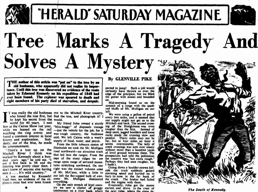
An excerpt from newspaper article about the tragedy and mystery involving Kennedy’s death. To read the full article click here. Source: “HERALD” SATURDAY MAGAZINE (1949, October 1). The Sydney Morning Herald (NSW : 1842 – 1954), p. 7.
Click here to read about Cunningham County
Click here to read about the county of Ashburnham
Parkes Shire Library would like to thank the following people and organisations for their assistance with this blog post:
- State Library & the Document Supply Service;
- Australian Dictionary of Biography website;
- staff of Parkes Shire Libraries;
- Trove;
- All 4 Adventure
If you have stories of Ashburnham county that you are willing to share please contact Parkes Shire Library via library@parkes.nsw.gov.au so that they can be shared and kept for posterity on this blog. Alternatively you may leave comments on this page.
REFERENCE LIST
- County / Parish Maps Guide. (September 8, 2016). Retrieved January 18, 2018, from https://www.records.nsw.gov.au/archives/collections-and-research/guides-and-indexes/county-parish-maps-guide
- Jansen, A. (1999). County & Parish Maps of N.S.W. with index (map). Emu Plains, NSW: Genial Enterprises. page 74
- Bruceanthro. (2010, May 8). Edmund Kennedy [Picture or drawing of early Australian explorer/surveyor, Edmund Kennedy, originally published in T.L.Mitchell (1838) “Three Expeditions into the interior of eastern Australia”.]. Retrieved January 19, 2018, from https://en.wikipedia.org/wiki/File:EdmundKennedy01.jpg
- Edgar Beale, ‘Kennedy, Edmund Besley (1818–1848)’, Australian Dictionary of Biography, National Centre of Biography, Australian National University, http://adb.anu.edu.au/biography/kennedy-edmund-besley-2297/text2967, published first in hardcopy 1967, accessed online 18 January 2018
At A Glance Images (clockwise from top right corner)
- Virtual Museum of Surveying. (n.d.). Transit Theodolite [The Surveyor’s Basic Tools]. Retrieved January 19, 2018, from http://www.surveyhistory.org/the_surveyor’s_basic_tools.htm
- Summerdrought (March 5, 2014) Kennedy’s Expeditions [Map] In Wikipedia Retrieved January 18, 2018 from https://commons.wikimedia.org/wiki/File:Kennedy_map_v2.png
- Tilley, R. (2005). Road Sign [Distance sign showing the Kennedy Highway & Captain Cook Highway Duplex, westbound at Smithfield]. Retrieved January 19, 2018, from http://www.expressway.online/oldsite/photogallery/roads/qld/numbered/nr1/kennedyhwy/index.htm
- Elixabeth College [Digital image]. (n.d.). Retrieved January 19, 2018, from http://elizabethcollege.gg/about-elizabeth-college/contact-us
- Jansen, A. (1999). County & Parish Maps of N.S.W. with index (map). Emu Plains, NSW: Genial Enterprises. page 5
- Roke (March 8, 2007) New South Wales Cadastral Divisions. Found on Wikipedia website which was made from public domain map in National Library Collection (http://nla.gov.au/nla.obj-229895917/view) Retrieved January 18, 2018 from https://commons.wikimedia.org/wiki/File:New_South_Wales_cadastral_divisions.png
- New South Wales. Department of Lands. (1960). County of Kennedy, Central Division, N.S.W. 1929 Retrieved January 22, 2018, from http://nla.gov.au/nla.obj-233901529
- Joy, William (1964). The Explorers. Adelaide: Rigby Ltd
- Beale, E. (1966). Australian Dictionary of Biography(Vol. 2, 1788-1850) (D. Pike, Ed.). Carlton, Victoria: Melbourne University Press; page 43 doi:http://adb.anu.edu.au/biography/kennedy-edmund-besley-2297
- Wittylama. (2012, March 13). Barcoo River [A section of the Barcoo River near to Tambo, Queensland. There had been recent severe flooding. On the riverbanks grow Eucalyptus camaldulensis.]. Retrieved January 22, 2018, from https://commons.wikimedia.org/wiki/File:Barcoo_river,_Tambo.JPG
- The Explorers [Edmund Kennedy & Jacky Jacky [sic]]. (n.d.). Retrieved January 19, 2018, from https://eachamhistorical.org/local-history/
- Andrews, J. (Producer). (2015, November 29). Campfire Stories – Edmund Kennedy [Television series episode]. In All 4 Adventure – Secrets of the Cape. Sydney, NSW: Ten Network. Retrieved January 19, 2018, from https://www.all4adventure.com/
- “HERALD” SATURDAY MAGAZINE (1949, October 1). The Sydney Morning Herald (NSW : 1842 – 1954), p. 7. Retrieved January 18, 2018, from http://nla.gov.au/nla.news-article18135482
